| Newport, RI HARBOR WALK SOUTH [ Main Harbor ] [map here] ... the Unmatchable Waterfront Walk |
 |
| Newport Harbor
Walk Newport Harbor
Walk North New Animated and GPS-Based Google Map Instructions [Beta Test] Also See: Newport Cliff Walk and Newport's Ten Mile Drive |
|
 Harbor Walk South covers Newport's busy downtown waterfront
area of the Main Harbor. Shipyard, State Fishing Fleet Pier,
Marinas, Restaurants, Shops, and everything else imaginable for a world
renowned sailing capital are here in one form or another. Harbor Walk South covers Newport's busy downtown waterfront
area of the Main Harbor. Shipyard, State Fishing Fleet Pier,
Marinas, Restaurants, Shops, and everything else imaginable for a world
renowned sailing capital are here in one form or another.
It's a 350-year-old seaport evolved over centuries. Here is a prime example of a hard working colonial shipping center converted into modern day tourist mecca. Almost anywhere along the harborfront provides great viewing for the crowd drawing fireworks during the Fourth of July weekend, for sailboats of every shape size and description, and for some pretty impressive powerships some equipped with their own helicopters. If there are no signs telling you to stay away, feel free to explore. |
|
| 1. The marina docks are mostly off limits. Recently under work were a house boat, tall ship, fishing trawler, Coast Guard ship, state-of-the-art ocean sailboat racer, in addition to other sailboats and power craft of all descriptions from all parts of the world. A breakfast/lunch shop offers outdoor tables dockside. The shipyard also serves as headquarters to a variety of major races during the season including the Transatlantic Race and a variety of national and international One Design Class regattas. The best view of the mega yachts is from the public observation dock which runs right along the south side of the Goat Island Causeway. |
|
|
This small park is dedicated to Ferrazzolli for her work over 25 years with Newport's Friends of the Waterfront to build public access to the waterfront, and in part for her support to keep the fishing fleet in Newport. At the park the walk starts to be a Walking Explorer's Dream ... with twists and turns ... with marked and unmarked links. Look for the Harbor Walk Signs [but more are needed]. Walk halfway out Washington Pier, take a right across the deck at Inn on Long Wharf, head across the gravel parking along the seawall and through a partly closed fence into the parking lot for Newport Yacht Club. The Marriott Hotel on the north side of Long Wharf is actually built on filled land over the colonial age coastal marsh. |
|
| 3. Here cruise ships ferry in their passengers for a day in the city; the Newport/Block Island Ferry stops; the Newport Harbor Shuttle stops; the Jamestown/Newport Ferry stops; there is a public dinghy dock, and boaters can dock by the hour. The Newport’s Harbormaster office [on the south end of the park] has a second floor observation deck open to the public, and it is a great observation platform for that special photo of the moored boats in the harbor especially in the morning when the sun is right. |
|
|
Turn right [west] to to Market Square, Bowens Wharf, and the old Ferry Landing site where you will see the Seaman's Institute and Aquidneck Lobster, The Ferry was replaced by the Newport Bridge in 1969 and the Newport Harbor Marina and Hotel now stands on the old ferry parking lot. The Seaman’s Church Institute has provided (since 1919), and continues to provide, services to boaters, and those who work on the sea such as commercial fishermen. Public facilities include restrooms, showers, washers, and dryers. A small but great restaurant offers family style breakfast and lunch for visitors. Adjacent to Bowen’s Wharf on the south is Bannister’s Wharf which also contains many historic buildings converted to shops as well as numerous sailing services. Here is the real start of the marina and boating aspect of the Main Harbor. Schooners docked here handle short trips into Narragansett Bay's East Passage. Just beyond Bannisters Wharf on the water is Old Port Marine, the main launch service for Newport Harbor with trips hourly around and across the harbor to Ft. Adams. One of the main attractions on the Newport Waterfront was the Newport Yachting Center built on one of the old ship building sites which was home to many of the America Cup teams. The Center had in the past hosted the Newport Boat Show, but was recently sold. This area is now being developed for more vacation related uses. |
|
| 5. Perry Mill was built in 1835 by Alexander MacGregor (Fort Adams, Newport Armory) to be a textile mill. Although Perry Mill was intended to stimulate Newport’s failing economy in the early nineteenth century by producing printed cloth, it ultimately was unsuccessful and in 1947 used by General Electric Co. for its light manufacturing. Now it combines shops and tavern on the first floor with the Newport Bay Club & Hotel above. At the Perry Mill building, the walk takes a slight right onto Thames Street. Here is another great exploratory diversion ... go west on Perry Mill Wharf and cut south through Christie's patio, across North 41's parking lot, through the tunnel in the Harborside Inn, across the front deck of the Inn on the Harbor to walk out to the gazebo on Ann St. Pier. On the shoreline of the pier is the Newport Maritime Center in the lower level of the Armory with restrooms, and indoor lunch tables for walkers. The Armory was built in 1884 to house the RI Militia and was the official headquarters for the last America’s Cup races in Newport in 1983. Ann Street Pier offers scenic views of Newport’s waterfront and a close up look at docks mostly for large power boats on each side. Right past the Greek Church on Thames Street is the Francis Malbone House built in 1758. The house’s original owner was a wealthy merchant and slave trader. Subterranean passages were found in the cellar of the house that lead to the waterfront and some propose that these passages could have been used to smuggle dutiable goods into the house. Speaking of smuggling, this part of the waterfront was home to many fishing boats in the early half of the last century. During prohibition, Newport was a major port for Canadian and Scotch wiskey that arrived in fishing boats daily. |
|
| 6. Just past Brown and Howard’s Wharf on the left side of Thames St. is the Samuel Whitehorne House. This federal style house was built in 1811 for Captain Whitehorne, a weathly triangle trader [molasses, rum, slaves]. Whitehorne was involved in numerous business ventures including shipping, a distillery, a bank, and an iron foundry. Today the Whitehorne House is a museum run by the Newport Restoration Foundation that contains numerous priceless pieces of Townsend and Goddard furniture, antique rugs, and silver crafted by Newport silversmiths. The house is located on land owned by a rum distiller before the American Revolution. One of Newport's colonial industrial accidents involved a multi thousand gallon tank of molasses which collapsed and killed a half dozen people. Turn west on Howard Wharf to walk through the IYRS 2.5 acre campus. The building facing on Thames was the city's electric generating plant built in 1903, and next to it was a textile mill from 1831 that houses the Museum of Yachting. Behind these buildings is a large temporary barn that houses the 1885 133-foot schooner yacht Coronet which is basically being entirely reconstructed. Walk around the outside edge of this barn and climb the stair inside to get a up close look. Further down Thames Street on the right is Lee’s Wharf home to Williams and Manchester Shipyard for most of the 1900s. This shipyard was the scene of most of the activity during Newport's series of America’s Cups. As you walk out of IYRS cut across the driftways of Spring Wharf, West Extension St and Waites Wharf. There are public rights of way at the waters edge. Then return to Thames St. to continue south. |
|
|
Newport's Friends of the Waterfront collaborated with members of the Coddington Wharf Condominum Association to build a garden pocket park and pathway here. The Wellington is built on the site of a coal gasification plant which supplied gas throughout the city from 1905 to 1950. Coal was shipped to Coddington Wharf on barges and then heated up to release gas. Cross country gas line construction eliminated the need for this plant. There is a 15ft. by 650ft. pedestrian right of way along the stone bulkhead that connects Coddington Wharf to King Park. Again Friends of the Waterfront provided much of the research resulting in a compromise elimination of the public Richmond St. in exchange for this waterfront pedestrian right of way. This allowed the developers a solid block of land. It took the better part of 40 years to convert this gas and oil tank contaminated site into the current time share resort and condo area. The waterfront in this corner of the harbor is shallow and no boats are moored close to shore. |
|
|
The area closest to Thames St. is the main picnic and land-based-activity segment of the park. One of the first Little League fields is the nation is right at waterside. Little League runs during May and June at the Harry Hogan Field with all the baseball park excitement when the games are in play. Softball and the Babe Ruth League are here as well. It is hard to beat the view that surrounds these baseball fields. Restrooms, slides, swings, grills, and a large gazebo structure cover picnic tables to round out the facilities. Benches line the waterfront so any one can watch the harbor. Seagulls are the main bird here, but during the year small flocks of Canadian geese like to congregate near the shore. |
|
|
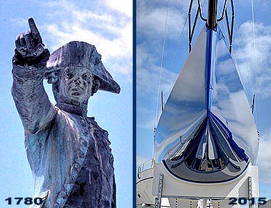
The 5000 French troops marched up and through the town and camped in an apple orchard area about where Bellevue and Narraganset Avenues intersect. It took nearly a year for Rochambeau and Washington to coordinate the plan and forces for attack that led to the last major action in that war. In 1781 British General Cornwallis surrendered his army and attached navy forces at Yorktown Va. In 1783 the Treaty of Paris was signed which acknowledged the end of the eight year revolutionary war, and created the United States as a completely independent nation. In total over 44,000 French soldiers participated in the war for US independence. Just east of the Rochambeau monument is the King Park Gazebo which provides the park with an exceptional bandstand for summer city concerts and events. Newly weds often are photographed posing at the bandstand as it is an icon for the Newport Waterfront with the city and harbor as a background. West of the monument is a small city beach generally without lifeguards. Directly in front of the park is one of four city boat mooring areas. This Spindle mooring area has a waiting list time of about 15 years. Along the seawall is a paved walk that was donated to the city and an integrated part of Harbor Walk. About the Sculpture |
|
|
To the west is the Ida Lewis Yacht Club on Lime Rock. Ida, born in 1842, was the daughter of the lighthouse keeper, and was appointed as the official lighthouse keeper in 1879 -- one of the first woman keepers in the U.S. She became nationally famous for her skill and courage in saving the lives of at least 18 accident victims from the waters of Newport Harbor and received the Congressional Lifesaving Award. After her death in 1911, the light was automated and connected to the shore by a long pier. Ida Lewis Yacht Club (ILYC) was launched in 1928 and remains very active. The next property southwest is the New York Yacht Club, which was originally the John Nicholas Brown estate, and has easily hosted regattas with attendance over 1500 people. Originally this summer branch of the New York based club was at the very opposite end of the harbor in the late 1800s. To the north is Sen. Claiborne Pell Bridge (also known as Newport Bridge) with a main span of 1600 ft. It ranks as the 86th longest suspension bridge in the world and the longest suspension bridge in New England. Completed in 1969, the clearance at the center is generally considered 204 ft and was adequate for U.S. Aircraft Carriers. The two main towers top out at 400 ft. |
|
| Map controls: 1. lower left corner box toggles
between sattelite or map view. 2. lower right + zooms in, - zooms out. 3. upper right [ ] expands to full screen. 4. cursor hand allows moving the map where you want. 5. colored symbols indicate relationship to text. |
|
| How to Open Map On Smart
Phone with GPS Positioning |
|
v.7.21.2015 copyright WebGhosts.com and PhotoGhosts.com Newport, RI 02840 and Naples, FL 34102 Maps are completely credited to Google, except for the magenta dots. This Newport Harbor Walk website remains under construction. We welcome information or photos anyone would like to share. Web Master |
|


